SOWEGA Weather

"SOWEGA" <---- where's that? SOWEGA refers to the southwestern portion of Georgia, epecially the Albany area. Many local businesses have adopted the SOWEGA (pronounced So-We-GAh) name. It's like the "Big Apple" for us southerners. SOWEGA Weather is a compliment to the local SKYWARN network of spotters, chasers, and local meteorologists (amateur and professional). It's not in competition with, but supplements, the activities of local weather nuts (like RL and JB).

Wednesday, February 21, 2007

Midnight rain


We might get a drop or two......


Tuesday, February 20, 2007

Tornado Drill postponed

Georgia's statewide tornado drill, previously scheduled for tomorrow morning, has been postponed due to possible inclement weather. Expect the drill to be conducted on Friday morning.

Before I forget.....

Two cool blogs of local interest:

http://swgeorgiawx.blogspot.com/

http://dewdropinsga.blogspot.com/

Weather at home


Here's a 10p.m. peek at the weather across Georgia, Alabama, and northern Florida.

From the Ft. Rucker, Alabama RADAR site (KEOX); Composite Reflectivity image captured with Gibson Ridge Software - Level 3 (free trial; $80 one-time fee; http://www.grlevelx.com).

Tonight's SWODY1 discussion


From http://spc.noaa.gov:

SBCAPES OF 600-700 J/KG AND VERY LITTLE CONVECTIVE INHIBITION
SBCAPE = Surface-based Convective Available Potential Energy; typically, the larger the number, the larger the risk of severe weather; however, CAPE > 400 can be significant in the right shearing environment. Assessed from a sounding, usually the positive area. Convective Inhibition (CIN) = negative area within a sounding; must be overcome ("the cap"); the smaller the amount, the better chance of convection (but, small amounts can allow parcels to explode through the positive area without inducing t'storms); usually, look for possible convection

UNDIRECTIONAL WIND FIELDS WITH 60-65 KTS OF 0-6 KM BULK SHEAR
0-6KM Bulk Shear = magnitude of shear between the two layers (surface and 6 km); >20 knots is significant and higher (>35) can indicate severity of the storm; however, no level of shear can accurately predict whether a supercell will be tornadic.

WITH 300-350 M2/S2 0-1 KM SRH
SRH = storm-relative helicity; vorticity, velocity, and relative storm-motion are calculated; >100 indicates supercell initiation, with higher levels (>200) may hint at possible tornado intensity.

What's a slight risk?

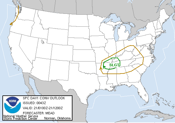
The SWODY1 (severe weather outlook day 1) forecast is produced by the meteorologists at the Storm Prediction Center in Norman, OK. Of course, you know them well as the originators of convective watches (tornado & severe thunderstorm).

The SWODY1 is originated daily at 0600 Zulu (Greenwich Mean Time) and updated at 1300, 1630, 2000, and 0100 Zulu (right now, it's 0240 Z = 9:40PM). The SWODY2 (day 2 outlook) is issued at 0800 & 1730 Zulu, and it covers the next day's possible events.

As posted earlier, the mid-south is under a Slight Risk today. Each risk category assumes an average area of 50,000 square miles. See today's risk at http://www.spc.noaa.gov

General Thunderstorm Risk = lowest risk category; usually discussed in the forecast text

Slight Risk = risk for 3 to 5 tornadoes; risk for 5-29 hail events (size at least one inch); risk for 5-29 wind events (severe wind levels; >57mph)

Moderate Risk = risk for 6-19 tornadoes; risk for at least 30 hail and/or wind events

High Risk = risk for at least tornadoes, of which 2 or more are expected to be EF-3 or greater; risk of at least 50 hail and/or wind events; risk for major severe weather outbreak

Weather in Ark, Ill, KY, MO, and TN


7am SWODY1 (Severe Weather Outlook Day One) = slight risk for severe t'storms across the mid-south (not deep south, though).
11am SWODY1 = sl risk for lower MS valley.
3pm SWODY1 = sl risk for lower MS valley into western TN valley
6pm WW#0026 = Severe T'storm Watch #26 issued for northeastern Arkansas, southern Illinois, western Kentucky, southeastern Missouri, and western Tennessee until 1am ET.
7pm SWODY1 = sl risk for parts of the mid-south (again, not deep south).
730pm Mesoscale Discussion (MD) #173 = severe t'storms with hail continue to occur over northern/northwestern sections of WW#26.


RADAR snap of area (from Memphis NWS RADAR; using Gibson Ridge Level 3) @ 7pm.